Symbols of the Islands

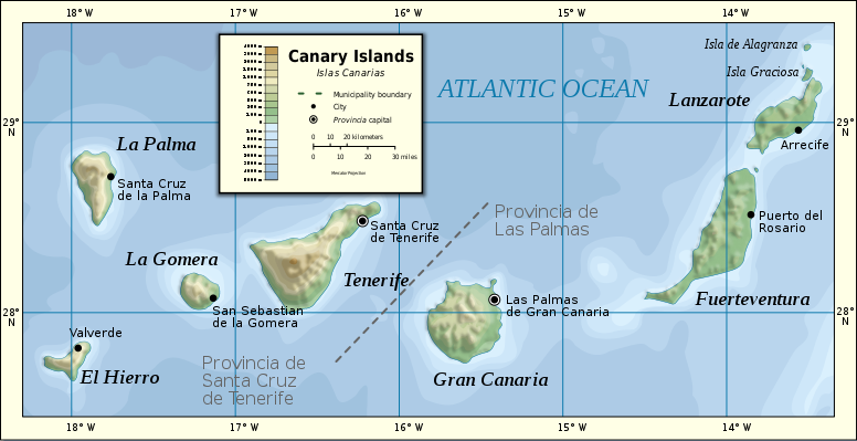
The Canary Islands are an autonomous community that forms a part of the Kingdom of Spain, and is made up of seven larger islands (Tenerife, La Palma, La Gomera, El Hierro, Gran Canaria, Lanzarote and Fuerteventura) and six smaller (Alegranza, Graciosa, Montaña Clara, Lobos, Roque del Este and Roque del Oeste). The archipelago is situated in the Atlantic Ocean, off the African coast; the northernmost point is 29º and the southernmost 27º N. The whole territory occupies 7447 km² and constitutes the Spanish region with the longest coastline: 1583 km.
It seems that the first inhabitants came to the islands from the north of the African continent in successive waves. The development of the prehistoric cultures allowed the setting up of a very hierarchical social organization, with a political structure of monarchical character and a set of collective organs that met to solve military, polítical or juridical issues. Though this culture is generally known as guanche, strictely speaking this name should be applied to the inhabitants of Tenerife only.
The Canary Islands were known in ancient times (Horatius and Plinius wrote about them), but it is since the 14th century when they began to be conquered by Europeans. It is known that, since 1291, several Genoese expeditions, followed by Catalans and Majorcans, arrived to the archipelago. In the 15th century, the conquest was promoted by the Norman noblemen Jéan de Bethencourt and Gadifer de la Salle, who were in the service of the Castilian Crown. The seizure of the islands was achieved with dificulties and took nearly the whole century. The aboriginals suffered huge losses of population during the conquest, and in the following years their ethnic and cultural identity was progressively diluted and faded away with the massive arrival of settlers from the Iberian Peninsula.
During the 15th and 16th centuries, the Real Audiencia (territorial high court) was set up, as well as the tribunal of the Inquisition, the episcopal see and the cabildos insulares (insular councils) which, chaired by a governor (chosen by the king or the corresponding lord in some islands), ruled over the respective island.
In the 18th century the authority was transferred to the general commandants, appointed by the Crown, to the detriment of the powers of the cabildos and the audiencia.
From 1871 onwards, the Canarian emigration to Latin America became very important, a trend that strengthened throughout the 20th century, especially to Cuba and Venezuela, being of an essential importance for the formation of the Canarian cultural identity.
The autonomous community is dividided, since 1927, into two provinces: Las Palmas —encompassing Gran Canaria, Fuerteventura and Lanzarote— and Santa Cruz de Tenerife —with the islands of Tenerife, La Gomera, El Hierro and La Palma—. Furthermore, every island is considered as an administrative unit ruled by an insular council.
The Statute of Autonomy of the Canary Islands was approved on 10 August 1982. The transfer of administrative and political competences from Madrid gave, from the first moment, a wide degree of self-government. Due to a historical rivalry between the two provinces, the community established a double capital: Santa Cruz de Tenerife and Las Palmas de Gran Canaria. The insular councils, created in their modern version in 1912, have great financial autonomy and wide administrative competences.
